26 Fevereiro 2017 – Pre O – COUDELARIA DE ALTER
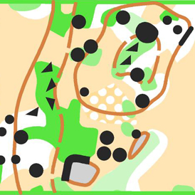
Mapa (Novo): Coudelaria de Alter – Escala 1/5.000, equidistância 5m, segundo as normas ISSOM.
Terreno: Terreno típico de montado alentejano, de baixo relevo, com algumas zonas com oliveiras e elementos característicos rochosos e de vegetação. O percurso desenrola-se, na sua maioria, num percurso de terra batida, havendo o risco de ficar enlameado em caso de chuva, dificultando a progressão das cadeiras de rodas.
Cartógrafos: Tiago Aires e Raquel Costa (Maio 2016)
Traçador de Percursos: Filipe Dias e Rui Príncipe
Supervisor: Joaquim Margarido
Classes: Aberta e Paralímpica
Pontos cronometrados: 1X3
GPS: 39°13’20.2″N 7°41’10.7″W
Aviso: O evento realiza-se numa área privada onde normalmente é paga entrada. Cada participante deverá ser identificado através do seu peitoral no controlo de acesso.
Regulamento:
Aplica-se integralmente o Regulamento de Competições 2017 da Federação Portuguesa de Orientação (FPO); casos omissos serão decididos, pela organização, à luz do regulamento da IOF.
 |
 |
Mapa antigo – Coudelaria de Alter do Chão (2010) – VER AQUI
Arena
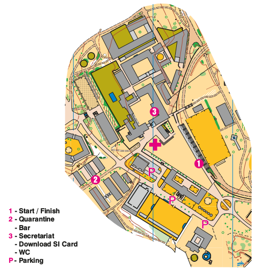
Outras Informações:
A organização disponibilizará voluntários para auxiliar na deslocação dos competidores em cadeiras de rodas.
O tempo limite para apresentação de reclamações é de 15 minutos após a publicação dos resultados, devendo as mesmas ser entregues no Secretariado.
Haverão duas estações cronometradas, com uma distância de 20 metros entre si e com os desafios comuns a ambos. A variação do ângulo de visualização entre ambas não coloca em causa a justiça desportiva.
Especificações:
| ESCALÃO | DISTÂNCIA (m) | DESNÍVEL (m) | CONTROLOS | PONTOS CRONOMETRADOS | ESCALA | EQUIDISTÂNCIA | TEMPO MÁXIMO DE PROVA |
|---|---|---|---|---|---|---|---|
| Aberto | 1570 | 10 | 23 | 1×3 | 1:5000 | 5m | 115 |
| Paralímpico | 1570 | 10 | 23 | 1×3 | 1:5000 | 5m | 130 |
Tempo máximo na estação cronometrada – 1 minuto e 30 segundos.