

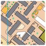
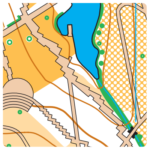
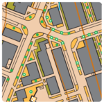
Map: Vila Nova de Santo André
Terrain: Urban zone with parks and gardens and small forest areas (pine trees).
All area is very flat.
Recent residential area very symmetric with several stairs, canopies and gardens around.
The constant change between urban and park areas will demand a high level of concentration.
Map maker: Updated and extended by Alexandre Reis Nov2019 -Jan 2020
Course planner: Alexandre Reis
Map scale: 1:4.000
Contour Interval: 2,5m
Parking: Area around the city market
Additional information:
– It is important to respect the instructions of the staff who will be managing the parking
– Distance from parking to starts – from 50 to 150 mts
– Distance from finish to parking – 300 mts
– SPORTident Air+ system will be active.
Final Technical Information
| Escalão/Class | Dist. (mts) | Desnível/Climb (mts) | Pontos/Controls |
|---|---|---|---|
| M10 | 1 520 | 17,5 | 13 |
| M12 | 1 700 | 22,5 | 13 |
| M14 | 2 070 | 20 | 14 |
| M16 | 3 080 | 40 | 18 |
| M18 | 3 250 | 40 | 19 |
| M20 | 3 870 | 52,5 | 22 |
| M21A | 3 960 | 52,5 | 22 |
| M21B | 2 070 | 20 | 14 |
| M21E | 4 190 | 55 | 24 |
| M21SE | 4 250 | 55 | 25 |
| M35 | 3 980 | 47,5 | 26 |
| M40 | 3 980 | 47,5 | 26 |
| M45 | 3 850 | 47,5 | 26 |
| M50 | 3 820 | 47,5 | 26 |
| M55 | 3 690 | 45 | 24 |
| M60 | 3 570 | 45 | 24 |
| M65 | 2 700 | 37,5 | 16 |
| M70 | 2 620 | 37,5 | 16 |
| M75 | 2 080 | 25 | 16 |
| M80 | 2 080 | 25 | 16 |
| M85 | 2 080 | 25 | 16 |
| W10 | 1 520 | 17,5 | 13 |
| W12 | 1 700 | 22,5 | 13 |
| W14 | 1 940 | 17,5 | 15 |
| W16 | 2 550 | 30 | 14 |
| W18 | 2 760 | 30 | 16 |
| W20 | 2 780 | 35 | 17 |
| W21B | 1 940 | 17,5 | 15 |
| W21A | 2 430 | 15,0 | 20 |
| W21E | 3 860 | 45 | 24 |
| W35 | 2 790 | 35 | 17 |
| W40 | 2 790 | 35 | 17 |
| W45 | 2 740 | 35 | 19 |
| W50 | 2 720 | 35 | 19 |
| W55 | 2 550 | 32,5 | 17 |
| W60 | 2 500 | 32,5 | 17 |
| W65 | 2 360 | 30 | 16 |
| W70 | 2 360 | 30 | 16 |
| W75 | 2 080 | 25 | 16 |
| W80 | 2 080 | 25 | 16 |
| W85 | 2 080 | 25 | 16 |
| Fácil Curto / Easy Short | 1 700 | 22,5 | 13 |
| Difícil Curto / Difficult Short | 2 500 | 30 | 15 |
| Fácil Longo / Easy Long | 3 280 | 32,5 | 20 |
| Difícil Longo / Difficult Long | 3 870 | 47,5 | 23 |
Map samples
 |
 |
 |