
Middle Distance GOLD WRE
Saturday, 14 February — Mira Norte
The first forest stage of the Portugal “O” Meeting 2026 will be a Middle Distance, counting for the Portuguese Orienteering Federation Cup Ranking, and with IOF GOLD WRE status.
Schedule
- Opening of the babysitting service (at the Arena): 09:00
- First start: 09:30 (starts are 850 metres away from the Arena)
- GOLD WRE prize-giving (Women Elite & Men Elite 1): 14:30
- Start window for Open and Beginner classes: 10:00–13:00
- Finish closure: 16:00
Traffic Flow and Parking
- Parking at the Arena Mira Norte will be arranged along a paved road and an unpaved dirt road.
To ensure that the process runs safely and efficiently, strict rules will be implemented and are mandatory for all POM 2026 participants.
- Access Rules for Mira Norte Arena
-
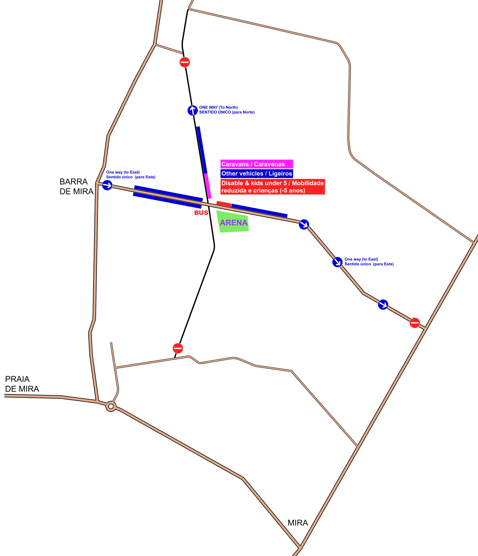
Access to Arena Mira Norte must be made exclusively via the village of Barra de Mira (west of the Arena):: 40.4888, -8.7833.
-
Once in Barra de Mira, drivers must follow the event signs, entering the Arena access road in the West → East direction.
-
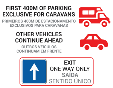
Traffic on the Arena access road is strictly one-way (West → East). As shown in the diagram below, it is not possible to access Arena Mira Norte from the East, South, or North.
-
Upon arrival at the parking area, drivers must strictly follow the organisers’ instructions. Vehicles will be directed to one of three parking areas:
a. Paved road before the Arena (west of the Arena);
b. Unpaved dirt road (north of the Arena);
c. Paved road after the Arena (east of the Arena). -
At the end of the stages:
a. Drivers parked on the paved road must continue eastwards;
b. Drivers parked on the dirt road must continue northwards;
c. U-turns are strictly forbidden. All drivers must comply with the mandatory traffic flow directions.
-
-
Motorhome and Caravan Parking
-
All motorhomes and caravans will be directed to the unpaved dirt road north of the Arena.
-
The first 400 metres of this road are reserved exclusively for motorhome and caravan parking.
-
All other passenger vehicles may only park beyond the area reserved for motorhomes and caravans, as indicated by the on-site signage.
-
-
Bus Parking
Bus parking will be provided at the junction located near the Arena (approximately 150 metres from the Arena):
40.4858, -8.7606.
Mira Norte Arena
- Arena location: 40.4846, -8.7587.
- Arena services: Restaurant/Bar (offering a wide range of meals and drinks throughout the day), Event Office, Babysitting, Finish, Speaker service, Toilets, and First Aid
- Refreshments: At the finish, athletes will be provided with water, lemon tea, and biscuits

Map Information
- Map – Mira Norte
- Mapping – Rafael Miguel (www.o-solutions.pt), June to December 2025
- Contour interval – 2,5 metres
- Symbols and Mapping Standards – the map was drawn according to the International Specification for Orienteering Maps 2017-2 issued by the International Orienteering Federation (IOF)


For more detailed information about the POM 2026 competition map, mapping specifications, and terrain, please refer to the page Mira Norte map – Forest stages
Courses
- Course Setter – Bruno Nazário
- Map Sheet Size – A4+ Portrait
IMPORTANT NOTICES
- Please be aware that there is an active Shooting Range within the Competition area, and gunfire may therefore be heard. Athletes should take this into account; however, there is no cause for concern.
- To the west of the competition area there is a kennel, and barking dogs may be heard. There is no cause for concern.
- Distance from the Arena to the Start – 850 metres
| Saturday Middle distance – GOLD World Ranking Event | ||||
|---|---|---|---|---|
| Class | Distance (km) | Climb (m) | Controls | Scale |
| Escalão | Distância (km) | Desnível (m) | Pontos | Escala |
| T10 | 2,5 km | 45 | 13 | 1:7500 |
| M12 | 3,3 km | 50 | 14 | 1:7500 |
| M14 | 3,6 km | 75 | 15 | 1:10000 |
| M16 | 4,1 km | 85 | 15 | 1:10000 |
| M18 | 5,1 km | 90 | 19 | 1:10000 |
| M20 | 5,5 km | 100 | 20 | 1:10000 |
| MB | 3,8 km | 70 | 15 | 1:10000 |
| M21A | 5,5 km | 95 | 18 | 1:10000 |
| M Elite 1 | 7,4 km | 135 | 25 | 1:10000 |
| M Elite 2 | 7,3 km | 130 | 24 | 1:10000 |
| M35 | 5,6 km | 105 | 20 | 1:10000 |
| M40 | 5,5 km | 100 | 20 | 1:10000 |
| M45 | 4,9 km | 95 | 19 | 1:10000 |
| M50 | 4,7 km | 95 | 17 | 1:10000 |
| M55 | 4,4 km | 80 | 15 | 1:10000 |
| M60 | 4,2 km | 75 | 15 | 1:10000 |
| M65 | 4,0 km | 80 | 15 | 1:7500 |
| M70 | 3,7 km | 75 | 14 | 1:7500 |
| M75 | 3,0 km | 55 | 13 | 1:7500 |
| M80 | 2,7 km | 60 | 11 | 1:7500 |
| M85 | 2,2 km | 35 | 11 | 1:7500 |
| M90 | 2,2 km | 35 | 11 | 1:7500 |
| W12 | 3,3 km | 50 | 14 | 1:7500 |
| W14 | 3,0 km | 65 | 12 | 1:10000 |
| W16 | 3,3 km | 70 | 13 | 1:10000 |
| W18 | 4,2 km | 70 | 16 | 1:10000 |
| W20 | 4,3 km | 85 | 16 | 1:10000 |
| WB | 3,0 km | 60 | 13 | 1:10000 |
| W21A | 4,5 km | 85 | 16 | 1:10000 |
| W Elite | 6,3 km | 120 | 24 | 1:10000 |
| W35 | 4,8 km | 95 | 18 | 1:10000 |
| W40 | 4,8 km | 95 | 18 | 1:10000 |
| W45 | 3,9 km | 80 | 15 | 1:10000 |
| W50 | 3,5 km | 75 | 12 | 1:10000 |
| W55 | 3,3 km | 70 | 14 | 1:10000 |
| W60 | 3,0 km | 60 | 12 | 1:10000 |
| W65 | 2,8 km | 55 | 13 | 1:7500 |
| W70 | 2,7 km | 60 | 11 | 1:7500 |
| W75 | 2,2 km | 40 | 9 | 1:7500 |
| W80 | 2,2 km | 35 | 11 | 1:7500 |
| W85 | 2,2 km | 35 | 11 | 1:7500 |
| Open White (Branco) | 2,5 km | 45 | 13 | 1:7500 |
| Open Green (Verde) | 3,4 km | 50 | 16 | 1:7500 |
| Open Yellow (Amarelo) | 4,0 km | 80 | 18 | 1:10000 |
| Open Red (Vermelho) | 5,0 km | 85 | 18 | 1:10000 |
Old Map
To view the previous Mira Norte map (covering only 5.5 km² of the current 25 km²), as well as the updated Dunas de Vagos map — now partly integrated into the Mira Norte map — please refer to the page Mira Norte map – Forest stages