
Long Distance Chasing Start
Tuesday, 17 February — Mira Norte
The second forest stage of the Portugal “O” Meeting 2026 will be a Long Distance venue and will count for the Portuguese Cup Ranking of the Portuguese Orienteering Federation.
Schedule
- Opening of the babysitting service (at the Arena): 08:30
- First start: 09:00 (starts are 1300 metres away from the Arena)
- Start window for Open and Beginner classes: 9:30–11:30
- POM 2026 Prize Giving Ceremony: 13:00
- Finish closure: 16:00
Traffic Flow and Parking
- Parking at the Arena Mira Norte will be arranged along a paved road and an unpaved dirt road.
To ensure that the process runs safely and efficiently, strict rules will be implemented and are mandatory for all POM 2026 participants.
- Access Rules for Mira Norte Arena
-
Access to Arena Mira Norte must be made exclusively via the village of Barra de Mira (west of the Arena):: 40.4888, -8.7833.
-
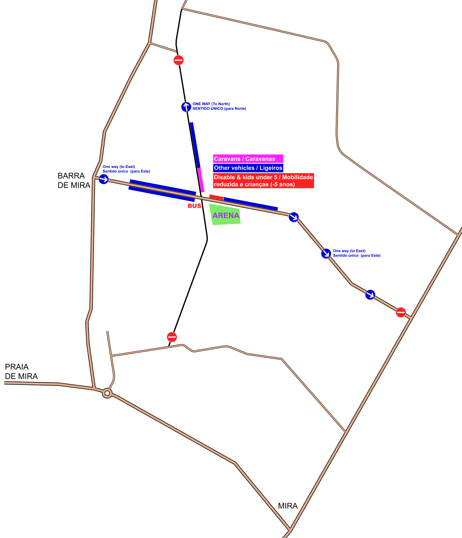
Once in Barra de Mira, drivers must follow the event signs, entering the Arena access road in the West → East direction.
-
Traffic on the Arena access road is strictly one-way (West → East). As shown in the diagram below, it is not possible to access Arena Mira Norte from the East, South, or North.
-
Upon arrival at the parking area, drivers must strictly follow the organisers’ instructions. Vehicles will be directed to one of three parking areas:
a. Paved road before the Arena (west of the Arena);
b. Unpaved dirt road (north of the Arena);
c. Paved road after the Arena (east of the Arena). -
At the end of the stages:
a. Drivers parked on the paved road must continue eastwards;
b. Drivers parked on the dirt road must continue northwards;
c. U-turns are strictly forbidden. All drivers must comply with the mandatory traffic flow directions.
-
-
Motorhome and Caravan Parking
-
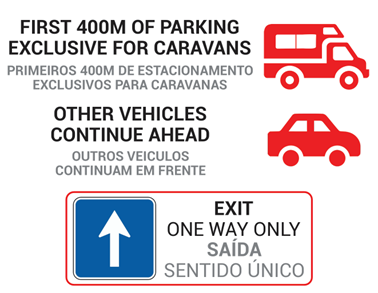
All motorhomes and caravans will be directed to the unpaved dirt road north of the Arena.
-
The first 400 metres of this road are reserved exclusively for motorhome and caravan parking.
-
All other passenger vehicles may only park beyond the area reserved for motorhomes and caravans, as indicated by the on-site signage.
-
-
Bus Parking
Bus parking will be provided at the junction located near the Arena (approximately 150 metres from the Arena):
40.4858, -8.7606.
Mira Norte Arena
- Arena location: 40.4846, -8.7587.
- Arena services: Restaurant/Bar (offering a wide range of meals and drinks throughout the day), Event Office, Babysitting, Finish, Speaker service, Toilets, and First Aid
- Refreshments: At the finish, athletes will be provided with water, lemon tea, and biscuits

Arena Passage
- There will be an Arena passage for the W Elite, M Elite 1, M Elite 2 and M 35 classes.
- These athletes will punch control 200 for the first time. After punching, they must follow the LEFT side of the corridor. This Arena passage is approximately 180 metres long.
- Afterwards, athletes will re-enter the forest for the final part of their courses.
- At the end, they will punch control 200 again and proceed towards the Finish, this time following the RIGHT side of the corridor.
- It is the athlete’s responsibility to choose the correct corridor, both during the Arena passage and at the finish.
- If, during the Arena passage, an athlete follows the right-hand corridor (finish corridor), there is a risk of deactivating the SIAC function of their chip. If this happens, the athlete may still continue the race to the end, punching in the traditional way (by inserting the SIAC into the control units).
- The Arena passage will be clearly identified with the sign shown.

Map Information
- Map – Mira Norte
- Mapping – Rafael Miguel (www.o-solutions.pt), June to December 2025
- Contour interval – 2,5 metres
- Symbols and Mapping Standards – the map was drawn according to the International Specification for Orienteering Maps 2017-2 issued by the International Orienteering Federation (IOF)


For more detailed information about the POM 2026 competition map, mapping specifications, and terrain, please refer to the page Mira Norte map – Forest stages
Courses
- Course Setter – Bruno Nazário
- Map Sheet Size – A4+ or A3+, depending of the athlete’s course
- Refreshments:
- There are several refreshment points distributed across the terrain.
- These locations are marked on the map with symbol 713 – Refreshment point.
- All refreshment points are located on tracks.
- Water and an isotonic drink provided by the brand SNUPE will be available at the refreshment points.
The T10, W12, M12, W14, W80, W85, M85, M90, Open Green and Open White courses have no refreshment points.
- Chasing Start start procedure
- Athletes will be called up 4 minutes before their start time. All athletes are kindly asked to proceed to the start area in good time — this is essential to ensure a smooth start procedure.
- There will be five start lanes. Each class will use only one start lane, according to the published start layout.
- Distance from the Arena to the Start – 1300 metres

| Tuesday Chasing Start Long distance | ||||
|---|---|---|---|---|
| Class | Distance (km) | Climb (m) | Controls | Scale |
| Escalão | Distância (km) | Desnível (m) | Pontos | Escala |
| T10 | 2.6 | 20 | 12 | 1:7500 |
| M12 | 3.2 | 35 | 13 | 1:7500 |
| M14 | 5.3 | 80 | 19 | 1:10000 |
| M16 | 7.2 | 100 | 20 | 1:10000 |
| M18 | 8.2 | 135 | 20 | 1:15000 |
| M20 | 10.8 | 170 | 27 | 1:15000 |
| MB | 7.1 | 85 | 21 | 1:10000 |
| M21A | 10.3 | 160 | 23 | 1:15000 |
| M Elite 1 | 15.8 | 300 | 30 | 1:15000 |
| M Elite 2 | 15.6 | 295 | 30 | 1:15000 |
| M35 | 11.8 | 215 | 24 | 1:10000 |
| M40 | 10 | 150 | 23 | 1:10000 |
| M45 | 9.4 | 145 | 25 | 1:10000 |
| M50 | 8.4 | 140 | 22 | 1:10000 |
| M55 | 7.3 | 100 | 18 | 1:10000 |
| M60 | 7.1 | 105 | 19 | 1:10000 |
| M65 | 6.4 | 80 | 17 | 1:7500 |
| M70 | 5.5 | 90 | 16 | 1:7500 |
| M75 | 4.8 | 75 | 13 | 1:7500 |
| M80 | 4 | 65 | 12 | 1:7500 |
| M85 | 2.8 | 40 | 10 | 1:7500 |
| M90 | 2.8 | 40 | 10 | 1:7500 |
| W12 | 3.2 | 35 | 13 | 1:7500 |
| W14 | 4.3 | 65 | 14 | 1:10000 |
| W16 | 5.9 | 80 | 17 | 1:10000 |
| W18 | 6.9 | 100 | 18 | 1:15000 |
| W20 | 8.7 | 135 | 22 | 1:15000 |
| WB | 4.6 | 70 | 17 | 1:10000 |
| W21A | 7.6 | 125 | 19 | 1:15000 |
| W Elite | 12.8 | 230 | 23 | 1:15000 |
| W35 | 6.5 | 80 | 17 | 1:10000 |
| W40 | 6.5 | 80 | 17 | 1:10000 |
| W45 | 5.8 | 90 | 16 | 1:10000 |
| W50 | 5.1 | 70 | 13 | 1:10000 |
| W55 | 4.9 | 60 | 16 | 1:10000 |
| W60 | 4.8 | 65 | 14 | 1:10000 |
| W65 | 4.2 | 65 | 14 | 1:7500 |
| W70 | 4 | 65 | 12 | 1:7500 |
| W75 | 3.1 | 50 | 10 | 1:7500 |
| W80 | 2.8 | 40 | 10 | 1:7500 |
| W85 | 2.8 | 40 | 10 | 1:7500 |
| Open White (Branco) | 2.6 | 20 | 12 | 1:7500 |
| Open Green (Verde) | 3.3 | 50 | 13 | 1:7500 |
| Open Yellow (Amarelo) | 4.7 | 70 | 17 | 1:10000 |
| Open Red (Vermelho) | 7.4 | 100 | 19 | 1:10000 |
Old Map
To view the previous Mira Norte map (covering only 5.5 km² of the current 25 km²), as well as the updated Dunas de Vagos map — now partly integrated into the Mira Norte map — please refer to the page Mira Norte map – Forest stages