

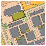
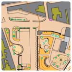
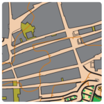
Map: Sines
Terrain: City that extends itself from the top of the hill until the Atlantic Ocean with a nice beach landscape.
An old urban area with irregular roads, within a castle, gardens and parks.
The courses will have some climb and will also go through some new residential areas.
Map maker: Luís Sérgio / Updated and extended by Alexandre Reis Nov2019 -Jan 2020
Course planner: Alexandre Reis
Map scale: 1:4.000
Contour Interval: 5m
Parking: Parking will be available around Sines Multi-Use Hall
– It is important to respect the instructions of the staff who will be managing the parking
Additional information:
– Distance from Parking to Starts – 800 mts (with Police help at the crosswalk in the IC33 road)
– Distance from Finish to parking: 450 mts
– SPORTident Air+ system will be active.
Final Technical Information
| Escalão/Class | Dist. (mts) | Desnível/Climb (mts) | Pontos/Controls |
|---|---|---|---|
| M10 | 1 780 | 10 | 16 |
| M12 | 2 020 | 10 | 18 |
| M14 | 2 600 | 15 | 17 |
| M16 | 3 020 | 25 | 19 |
| M18 | 3 070 | 25 | 18 |
| M20 | 3 900 | 30 | 20 |
| M21A | 4 030 | 30 | 22 |
| M21B | 2 600 | 15 | 17 |
| M21E | 4 220 | 35 | 21 |
| M21SE | 4 260 | 35 | 21 |
| M35 | 3 900 | 30 | 20 |
| M40 | 3 900 | 30 | 20 |
| M45 | 3 800 | 30 | 20 |
| M50 | 3 790 | 30 | 19 |
| M55 | 3 690 | 25 | 21 |
| M60 | 3 570 | 25 | 19 |
| M65 | 2 950 | 20 | 19 |
| M70 | 2 770 | 20 | 17 |
| M75 | 1 980 | 10 | 17 |
| M80 | 1 980 | 10 | 17 |
| M85 | 1 980 | 10 | 17 |
| W10 | 1 780 | 10 | 16 |
| W12 | 2 020 | 10 | 18 |
| W14 | 2 350 | 15 | 15 |
| W16 | 2 470 | 20 | 15 |
| W18 | 2 660 | 20 | 16 |
| W20 | 2 720 | 20 | 17 |
| W21B | 2 350 | 15 | 15 |
| W21A | 2 700 | 20 | 15 |
| W21E | 3 850 | 30 | 21 |
| W35 | 3 090 | 25 | 16 |
| W40 | 3 090 | 25 | 16 |
| W45 | 2 870 | 20 | 17 |
| W50 | 2 690 | 20 | 17 |
| W55 | 2 690 | 20 | 15 |
| W60 | 2 450 | 20 | 16 |
| W65 | 2 400 | 15 | 17 |
| W70 | 2 400 | 15 | 17 |
| W75 | 1 980 | 10 | 17 |
| W80 | 1 980 | 10 | 17 |
| W85 | 1 980 | 10 | 17 |
| Fácil Curto / Easy Short | 2 020 | 10 | 18 |
| Difícil Curto / Difficult Short | 2 580 | 15 | 15 |
| Fácil Longo / Easy Long | 2 710 | 20 | 21 |
| Difícil Longo / Difficult Long | 3 960 | 25 | 21 |
Map samples
 |
 |
 |